1.
The Eiffel Tower
The
Eiffel Tower (French:
La tour Eiffel,
[tuʁ ɛfɛl]) is an
iron lattice tower located on the
Champ de Mars in
Paris. It was named after the engineer
Gustave Eiffel, whose company designed and built the tower. Erected in 1889 as the entrance arch to the
1889 World's Fair,
it was initially criticised by some of France's leading artists and
intellectuals for its design, but has become both a global
cultural icon of
France and one of the most recognizable structures in the world.
[1] The tower is the
tallest structure in Paris and the most-visited paid monument in the world; 6.98 million people ascended it in 2011.
[2] The tower received its 250 millionth visitor in 2010.
[2]
The tower is 324 metres (1,063 ft) tall,
[2] about the same height as an 81-storey building. During its construction, the Eiffel Tower surpassed the
Washington Monument to assume the title of the
tallest man-made structure in the world, a title it held for 41 years, until the
Chrysler Building in
New York City
was built in 1930. Because of the addition of the aerial atop the
Eiffel Tower in 1957, it is now taller than the Chrysler Building by 5.2
metres (17 ft). Not including
broadcast aerials, it is the
second-tallest structure in France, after the
Millau Viaduct.
The tower has three levels for visitors, with restaurants on the
first and second. The third level observatory's upper platform is 276 m
(906 ft) above the ground,
[2] the highest accessible to the public in the
European Union. Tickets can be purchased to ascend by
stairs or
lift
(elevator) to the first and second levels. The climb from ground level
to the first level is over 300 steps, as is the walk from the first to
the second level. Although there are stairs to the third and highest
level, these are usually closed to the public and it is generally only
accessible by lift.
2. Seine River

The
Seine (
//;
French:
La Seine,
pronounced: [la sɛːn]) is a 776 km long river and an important commercial waterway within the
Paris Basin in the north of France. It rises at
Source-Seine, 30 kilometers northwest of
Dijon in northeastern France in the
Langres plateau, flowing through Paris and into the
English Channel at
Le Havre (and
Honfleur on the left bank).
[1] It is navigable by ocean-going vessels as far as
Rouen, 120 km (75 mi) from the sea. Over 60% of its length, as far as
Burgundy, is negotiable by commercial riverboats and nearly its whole length is available for recreational boating;
excursion boats offer sightseeing tours of the
Rive Droite and
Rive Gauche within the city of Paris.

There are 37
bridges within Paris and dozens more
spanning the river outside the city. Examples in Paris include the
Pont Louis-Philippe and
Pont Neuf, the latter of which dates back to 1607. Outside the city, examples include the
Pont de Normandie, one of the longest
cable-stayed bridges in the world, which links Le Havre to
Honfleur.
3. The Louvre

The
Louvre or the
Louvre Museum (
French:
Musée du Louvre,
pronounced: [myze dy luvʁ]) is one of the world's largest
museums and a historic monument. A central landmark of
Paris, France, it is located on the
Right Bank of the
Seine in the
1st arrondissement
(district). Nearly 35,000 objects from prehistory to the 21st century
are exhibited over an area of 60,600 square metres (652,300 square
feet). The Louvre is the world's most visited museum, and received more
than 9.7 million visitors in 2012.
[1]

The museum is housed in the
Louvre Palace, originally built as a fortress in the late 12th century under
Philip II.
Remnants of the fortress are visible in the basement of the museum. The
building was extended many times to form the present Louvre Palace. In
1682,
Louis XIV chose the
Palace of Versailles
for his household, leaving the Louvre primarily as a place to display
the royal collection, including, from 1692, a collection of ancient
Greek and Roman sculpture.
[2] In 1692, the building was occupied by the
Académie des Inscriptions et Belles Lettres and the
Académie Royale de Peinture et de Sculpture, which in 1699 held the first of a series of salons. The Académie remained at the Louvre for 100 years.
[3] During the
French Revolution, the
National Assembly decreed that the Louvre should be used as a museum to display the nation's masterpieces.

The
Mona Lisa, (
Leonardo da Vinci), oil on panel, 1503–19, probably completed while the artist was at the court of
Francis I.
The museum opened on 10 August 1793 with an exhibition of
537 paintings, the majority of the works being royal and confiscated
church property. Because of structural problems with the building, the
museum was closed in 1796 until 1801. The collection was increased under
Napoleon and the museum renamed the
Musée Napoléon,
but after Napoleon's abdication many works seized by his armies were
returned to their original owners. The collection was further increased
during the reigns of
Louis XVIII and
Charles X, and during the
Second French Empire the museum gained 20,000 pieces. Holdings have grown steadily through donations and gifts since the
Third Republic. As of 2008, the collection is divided among eight curatorial departments:
Egyptian Antiquities;
Near Eastern Antiquities; Greek,
Etruscan, and
Roman Antiquities;
Islamic Art;
Sculpture;
Decorative Arts; Paintings; Prints and Drawings.
4. Palace of Versailles

The
Palace of Versailles (
English // vair-SY or
// vər-SY;
French: [vɛʁˈsɑj]), or simply
Versailles, is a royal
château in
Versailles in the
Île-de-France region of France. In French, it is known as the
Château de Versailles.
When the château was built, Versailles was a country village; today, however, it is a wealthy suburb of
Paris,
some 20 kilometers southwest of the French capital. The court of
Versailles was the center of political power in France from 1682, when
Louis XIV moved from Paris, until the
royal family was forced to return to the capital in October 1789 after the beginning of the
French Revolution. Versailles is therefore famous not only as a building, but as a symbol of the system of
absolute monarchy of the
Ancien Régime.

The earliest mention of the name of Versailles is in a document dated
1038, relating to the village of Versailles. In 1575, the seigneury of
Versailles was bought by
Albert de Gondi, a naturalized Florentine, who invited
Louis XIII
on several hunting trips in the forests surrounding Versailles. Pleased
with the location, Louis ordered the construction of a hunting lodge in
1624. Eight years later, Louis obtained the seigneury of Versailles
from the Gondi family and began to make enlargements to the château.
This structure would become the core of the new palace.
[1] Louis XIII's successor,
Louis XIV, had it expanded into one of the largest palaces in the world.
[2] Following the
Treaties of Nijmegen in 1678, he began to gradually move the court to Versailles. The court was officially established there on 6 May 1682.
[3]
After the disgrace of
Nicolas Fouquet in 1661, Louis confiscated Fouquet's estate and employed the talents of
Le Vau,
Le Nôtre,
and Le Brun, who all had worked on Fouquet's grand château
Vaux-le-Vicomte, for his building campaigns at Versailles and elsewhere.
For Versailles, there were four distinct building campaigns.
[4]
The four building campaigns (1664–1710)
View of the Palace from the garden
The first building campaign (1664–1668) commenced with the
Plaisirs de l'Île enchantée (Pleasures of the Enchanted Island) of 1664, a
fête
that was held between 7 and 13 May 1664. The campaign involved
alterations in the château and gardens to accommodate the 600 guests
invited to the party.
[5]
The second building campaign (1669–1672) was inaugurated with the signing of the
Treaty of Aix-la-Chapelle,
which ended the War of Devolution. During this campaign, the château
began to assume some of the appearance that it has today. The most
important modification of the château was Le Vau's envelope of Louis
XIII's hunting lodge.
[6] Significant to the design and construction of the
grands appartements
is that the rooms of both apartments are of the same configuration and
dimensions—a hitherto unprecedented feature in French palace design.
Both the
grand appartement du roi and the
grand appartement de la reine formed a suite of seven
enfilade
rooms. The decoration of the rooms, which was conducted under Le Brun's
direction, depicted the "heroic actions of the king" and were
represented in allegorical form by the actions of historical figures
from the antique past (
Alexander the Great,
Augustus,
Cyrus, etc.).
[7]

With the signing of the
Treaty of Nijmegen in 1678, which ended the
Dutch War, the third building campaign at Versailles began (1678–1684). Under the direction of the architect,
Jules Hardouin-Mansart,
the Palace of Versailles acquired much of the look that it has today.
In addition to the Hall of Mirrors, Hardouin-Mansart designed the north
and south
wings and the
Orangerie. Le Brun was occupied not only with the
interior decoration of the new additions of the palace, but also collaborated with Le Nôtre's in landscaping the palace gardens.
[8]

Soon after the defeat of the
War of the League of Augsburg
(1688–1697), Louis XIV undertook his last building campaign at
Versailles. The fourth building campaign (1699–1710) concentrated almost
exclusively on construction of the royal chapel designed by
Hardouin-Mansart and finished by
Robert de Cotte. There were also some modifications in the
appartement du roi, namely the construction of the
Salon de l'Œil de Bœuf and the
King's Bedchamber.
With the completion of the chapel in 1710, virtually all construction
at Versailles ceased; building would not be resumed at Versailles until
some twenty one years later during the reign of
Louis XV.
[9]
5. Chartres Cathedral
 Chartres Cathedral
, also known as
Cathedral Basilica of Our Lady of Chartres (
French:
Basilique Cathédrale Notre-Dame de Chartres), is a
medieval Catholic cathedral of the
Latin Church located in
Chartres, France, about 80 kilometres (50 mi) southwest of Paris. It is considered one of the finest examples of French
Gothic architecture and is a
UNESCO World Heritage Site.
The current cathedral, mostly constructed between 1194 and 1250, is the
last of at least five which have occupied the site since the town
became a
bishopric in the 4th century.
The cathedral is in an exceptional state of preservation. The
majority of the original stained glass windows survive intact, while the
architecture has seen only minor changes since the early 13th century.
The building's exterior is dominated by heavy
flying buttresses
which allowed the architects to increase the window size significantly,
while the west end is dominated by two contrasting spires – a 105-metre
(349 ft) plain pyramid completed around 1160 and a 113-metre (377 ft)
early 16th-century
Flamboyant
spire on top of an older tower. Equally notable are the three great
façades, each adorned with hundreds of sculpted figures illustrating key
theological themes and narratives.

Since at least the 12th century the cathedral has been an important
destination for travellers – and remains so to this day, attracting
large numbers of Christian pilgrims, many of whom come to venerate its
famous relic, the
Sancta Camisa, said to be the tunic worn by the
Virgin Mary at Christ's birth, as well as large numbers of secular
tourists who come to admire the cathedral's architecture and historical
merit.
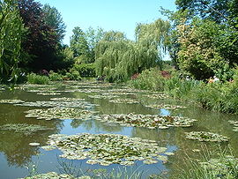
6. Giverny
Giverny (French pronunciation: [ʒi.vɛʁ.ni]) is a commune in the Eure department in northern France. It is best known as the location of Claude Monet's garden and home.

 A settlement has existed in Giverny since neolithic times and a monument uncovered attests to this fact. Archeological finds have included booties dating from Gallo-Roman times and to the earlier 1st and 2nd centuries AD.
The town was known in ancient deeds as "Warnacum". The cultivation of
grapes has been an occupation of the inhabitants of Giverny since Merovingian times. The village church dates from the Middle Ages and is built partially in the Romanesque style, though additions have since been made. It is dedicated to Sainte-Radegonde.
The village has remained a small rural setting with a modest population
(numbering around 301 in 1883 when Monet discovered it) and has since
seen a boom in tourism since the restoration of Monet's house and
gardens.
A settlement has existed in Giverny since neolithic times and a monument uncovered attests to this fact. Archeological finds have included booties dating from Gallo-Roman times and to the earlier 1st and 2nd centuries AD.
The town was known in ancient deeds as "Warnacum". The cultivation of
grapes has been an occupation of the inhabitants of Giverny since Merovingian times. The village church dates from the Middle Ages and is built partially in the Romanesque style, though additions have since been made. It is dedicated to Sainte-Radegonde.
The village has remained a small rural setting with a modest population
(numbering around 301 in 1883 when Monet discovered it) and has since
seen a boom in tourism since the restoration of Monet's house and
gardens.

 7. Arc de Triomphe
The Arc de Triomphe de l'Étoile (French pronunciation: [aʀk də tʀiɔ̃f də letwal], Arch of Triumph of the Star) is one of the most famous monuments in Paris. It stands in the centre of the Place Charles de Gaulle (originally named Place de l'Étoile), at the western end of the Champs-Élysées.[3] It should not be confused with a smaller arch, the Arc de Triomphe du Carrousel, which stands west of the Louvre. The Arc de Triomphe (in English: "Triumphal Arch") honours those who fought and died for France in the French Revolutionary and the Napoleonic Wars, with the names of all French victories and generals inscribed on its inner and outer surfaces. Beneath its vault lies the Tomb of the Unknown Soldier from World War I.
7. Arc de Triomphe
The Arc de Triomphe de l'Étoile (French pronunciation: [aʀk də tʀiɔ̃f də letwal], Arch of Triumph of the Star) is one of the most famous monuments in Paris. It stands in the centre of the Place Charles de Gaulle (originally named Place de l'Étoile), at the western end of the Champs-Élysées.[3] It should not be confused with a smaller arch, the Arc de Triomphe du Carrousel, which stands west of the Louvre. The Arc de Triomphe (in English: "Triumphal Arch") honours those who fought and died for France in the French Revolutionary and the Napoleonic Wars, with the names of all French victories and generals inscribed on its inner and outer surfaces. Beneath its vault lies the Tomb of the Unknown Soldier from World War I.

The Arc de Triomphe is the linchpin of the
Axe historique
(historic axis) – a sequence of monuments and grand thoroughfares on a
route which runs from the courtyard of the Louvre to the
Grande Arche de la Défense. The monument was designed by
Jean Chalgrin in 1806 and its
iconographic program pitted
heroically nude French youths against bearded
Germanic warriors in
chain mail. It set the tone for public monuments, with triumphant patriotic messages.
The monument stands 50 metres (164 ft) in height, 45 m (148 ft) wide
and 22 m (72 ft) deep. The large vault is 29.19 m (95.8 ft) high and
14.62 m (48.0 ft) wide. The small vault is 18.68 m (61.3 ft) high and
8.44 m (27.7 ft) wide. Its design was inspired by the Roman
Arch of Titus.
The Arc de Triomphe is built on such a large scale that, three weeks
after the Paris victory parade in 1919 (marking the end of hostilities
in World War I),
Charles Godefroy flew his
Nieuport biplane through it, with the event captured on newsreel.
[4][5][6]
It was the tallest
triumphal arch in existence until the completion of the
Monumento a la Revolución in
Mexico City in 1938, which is 67 metres (220 ft) high. The
Arch of Triumph in Pyongyang, completed in 1982, is modelled on the Arc de Triomphe and is slightly taller at 60 m (197 ft).

.png)